


Map of Somalia's states, regions, districts II
Moderators: Moderators, Junior Moderators
Forum rules
This General Forum is for general discussions from daily chitchat to more serious discussions among Somalinet Forums members. Please do not use it as your Personal Message center (PM). If you want to contact a particular person or a group of people, please use the PM feature. If you want to contact the moderators, pls PM them. If you insist leaving a public message for the mods or other members, it will be deleted.
This General Forum is for general discussions from daily chitchat to more serious discussions among Somalinet Forums members. Please do not use it as your Personal Message center (PM). If you want to contact a particular person or a group of people, please use the PM feature. If you want to contact the moderators, pls PM them. If you insist leaving a public message for the mods or other members, it will be deleted.
-
Alta Vista [Bot2]
- SomaliNetizen

- Posts: 497
- Joined: Mon Apr 30, 2001 7:00 pm
- Location: Carriga Ingiriisiga
-
James Dahl
- SomaliNet Super

- Posts: 5212
- Joined: Mon Dec 04, 2006 11:05 pm
- Location: Vancouver, British Columbia, Canada
- Contact:
Re: Map of Somalia's states, regions, districts II
You know, there isn't even any guarantee that they'll call it Jubbaland, that was what the Ogadeen & Harti called it when they created the state. Marehan are just as likely to dub it "Greater Gedo".
-
cabdallah252
- SomaliNet Heavyweight

- Posts: 3226
- Joined: Fri Apr 27, 2007 9:25 pm
- Location: Greater Majeerteeniya
Re: Map of Somalia's states, regions, districts II
since when does the juba river flow through galgaduud???
LOL
LOL
-
James Dahl
- SomaliNet Super
- Posts: 5212
- Joined: Mon Dec 04, 2006 11:05 pm
- Location: Vancouver, British Columbia, Canada
- Contact:
Re: Map of Somalia's states, regions, districts II
Marehan should just declare a state in Caabudwaq and claim Werder zone of Ethiopia.
Ethiopia's busy in Mogadishu and Eritrea.
Ethiopia's busy in Mogadishu and Eritrea.
-
Advocatar

- SomaliNet Super
- Posts: 9940
- Joined: Sat Sep 09, 2006 9:35 pm
- Location: Chilling In SANAAG, Makhiir State Of SOMALI, enjoying TUNA fish
Re: Map of Somalia's states, regions, districts II
Jubbaland State 4 lyfe...... 8)
-
Somali2003

- SomaliNet Heavyweight
- Posts: 1729
- Joined: Sun Oct 26, 2003 7:00 pm
- Location: GaadhHaye, Royal Army of Sultan M.
- Contact:
Re: Map of Somalia's states, regions, districts II
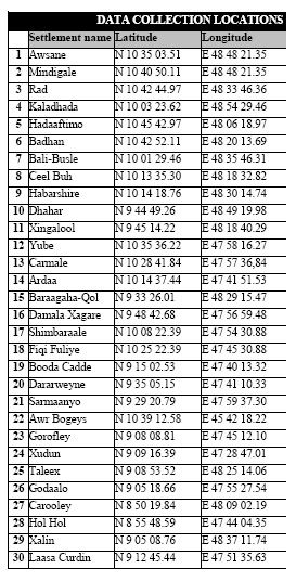
This one is good. Did you use the latitute longtitude info I gave in the other thread?
Where is Shimbiraale, that is really a major village town.
http://i168.photobucket.com/albums/u195 ... titude.jpg
Where is Shimbiraale, that is really a major village town.
http://i168.photobucket.com/albums/u195 ... titude.jpg
-
DawladSade

- SomaliNet Super
- Posts: 13940
- Joined: Fri Apr 22, 2005 9:38 pm
- Location: Xornimo
Re: Map of Somalia's states, regions, districts II
Northern Jubbaland is called Ximan State. 8)
[quote]You know, there isn't even any guarantee that they'll call it Jubbaland, that was what the Ogadeen & Harti called it when they created the state. Marehan are just as likely to dub it "Greater Gedo".[/quote]
So you are saying no one called it "Jubbaland" before then?
[quote]You know, there isn't even any guarantee that they'll call it Jubbaland, that was what the Ogadeen & Harti called it when they created the state. Marehan are just as likely to dub it "Greater Gedo".[/quote]
So you are saying no one called it "Jubbaland" before then?
-
Sadaam_Mariixmaan

- SomaliNet Super
- Posts: 13484
- Joined: Sat Feb 03, 2007 8:50 pm
- Location: Villa SADAAM, Jamuriyada Sadaamalia
- Contact:
Re: Map of Somalia's states, regions, districts II
Jubbaland State and Ximan State
8)
8)
-
James Dahl
- SomaliNet Super
- Posts: 5212
- Joined: Mon Dec 04, 2006 11:05 pm
- Location: Vancouver, British Columbia, Canada
- Contact:
Re: Map of Somalia's states, regions, districts II
[quote="DawladSade"]Northern Jubbaland is called Ximan State. 8)
[quote]You know, there isn't even any guarantee that they'll call it Jubbaland, that was what the Ogadeen & Harti called it when they created the state. Marehan are just as likely to dub it "Greater Gedo".[/quote]
So you are saying no one called it "Jubbaland" before then?[/quote]
The British and Italian era, before it was merged with Italian Somaliland, it was called Transjuba.
-
DawladSade
- SomaliNet Super
- Posts: 13940
- Joined: Fri Apr 22, 2005 9:38 pm
- Location: Xornimo
Re: Map of Somalia's states, regions, districts II
[quote="James Dahl"][quote="DawladSade"]Northern Jubbaland is called Ximan State. 8)
[quote]You know, there isn't even any guarantee that they'll call it Jubbaland, that was what the Ogadeen & Harti called it when they created the state. Marehan are just as likely to dub it "Greater Gedo".[/quote]
So you are saying no one called it "Jubbaland" before then?[/quote]
The British and Italian era, before it was merged with Italian Somaliland, it was called Transjuba.[/quote]
How should I respond to this?
-
Somali2003
- SomaliNet Heavyweight
- Posts: 1729
- Joined: Sun Oct 26, 2003 7:00 pm
- Location: GaadhHaye, Royal Army of Sultan M.
- Contact:
Re: Map of Somalia's states, regions, districts II
James, since you are cartographer, let me ask you to highlight Shimbiraale in your next adjustment. This town is important. You can get the info from the above link.
-
James Dahl
- SomaliNet Super
- Posts: 5212
- Joined: Mon Dec 04, 2006 11:05 pm
- Location: Vancouver, British Columbia, Canada
- Contact:
Re: Map of Somalia's states, regions, districts II
The map I made is a political map, with states regions and districts based on their political importance. For instance Bosaso is larger and economically more important than Garowe, but because Garowe is politically more important it is bigger.
I do want to put in important villages that aren't districts as well, but I'm working on a criteria. Also, things have changed dramatically across Somalia and there are dozens of new villages as well as dozens of abandoned/destroyed villages. Sorting that out is a job in itself.
The reason Shimbiraale was not on the map is it is not a district of Maakhir or Somaliland, it's just a town. It's a big town, bigger than a lot of Maakhiri districts probably, but since the map is a POLITICAL map, it isn't on there.
Towns like Shimbiraale should be on an economic or demographic map, showing either clans or economic activities. I don't think any single man has enough knowledge to make that map though, it would take a team of men across Somalia and years of research. Would be valuable map though.
-
Somali2003
- SomaliNet Heavyweight
- Posts: 1729
- Joined: Sun Oct 26, 2003 7:00 pm
- Location: GaadhHaye, Royal Army of Sultan M.
- Contact:
Re: Map of Somalia's states, regions, districts II
Shimbirale is not bigger than Yube. It is the same size as Yube but politically important town since it is closer to Erigavo.
I will p.m you my e-mail. I know two other guys. One is GIS engineer.
I will p.m you my e-mail. I know two other guys. One is GIS engineer.
-
- Similar Topics
- Replies
- Views
- Last post
-
- 122 Replies
- 8925 Views
-
Last post by Sangub
-
- 13 Replies
- 1854 Views
-
Last post by PrinceNugaalHawd
-
- 0 Replies
- 1811 Views
-
Last post by LiQaaye_TDH
-
- 39 Replies
- 3939 Views
-
Last post by MrSinister
-
- 7 Replies
- 1564 Views
-
Last post by Gubbet
-
- 14 Replies
- 2234 Views
-
Last post by Dhaga Bacayl
-
- 14 Replies
- 1590 Views
-
Last post by sahal80
-
- 17 Replies
- 2050 Views
-
Last post by X.Playa
-
- 0 Replies
- 615 Views
-
Last post by jamols2