Page 1 of 1
Map of Somalia's states, regions, districts II
Posted: Sat Sep 29, 2007 6:58 pm
by Alta Vista [Bot2]
Re: Map of Somalia's states, regions, districts II
Posted: Sat Sep 29, 2007 7:01 pm
by James Dahl
You know, there isn't even any guarantee that they'll call it Jubbaland, that was what the Ogadeen & Harti called it when they created the state. Marehan are just as likely to dub it "Greater Gedo".
Re: Map of Somalia's states, regions, districts II
Posted: Sat Sep 29, 2007 7:02 pm
by cabdallah252
Re: Map of Somalia's states, regions, districts II
Posted: Sat Sep 29, 2007 7:06 pm
by James Dahl
Marehan should just declare a state in Caabudwaq and claim Werder zone of Ethiopia.
Ethiopia's busy in Mogadishu and Eritrea.
Re: Map of Somalia's states, regions, districts II
Posted: Sat Sep 29, 2007 7:23 pm
by Advocatar
Jubbaland State 4 lyfe...... 8)
Re: Map of Somalia's states, regions, districts II
Posted: Sat Sep 29, 2007 7:23 pm
by Somali2003
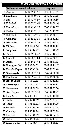
This one is good. Did you use the latitute longtitude info I gave in the other thread?
Where is Shimbiraale, that is really a major village town.
http://i168.photobucket.com/albums/u195 ... titude.jpg
Re: Map of Somalia's states, regions, districts II
Posted: Sat Sep 29, 2007 10:08 pm
by DawladSade
Northern Jubbaland is called Ximan State. 8)
[quote]You know, there isn't even any guarantee that they'll call it Jubbaland, that was what the Ogadeen & Harti called it when they created the state. Marehan are just as likely to dub it "Greater Gedo".[/quote]
So you are saying no one called it "Jubbaland" before then?
Re: Map of Somalia's states, regions, districts II
Posted: Sat Sep 29, 2007 10:11 pm
by Sadaam_Mariixmaan
Jubbaland State and Ximan State
8)

Re: Map of Somalia's states, regions, districts II
Posted: Sat Sep 29, 2007 10:20 pm
by James Dahl
[quote="DawladSade"]Northern Jubbaland is called Ximan State. 8)
[quote]You know, there isn't even any guarantee that they'll call it Jubbaland, that was what the Ogadeen & Harti called it when they created the state. Marehan are just as likely to dub it "Greater Gedo".[/quote]
So you are saying no one called it "Jubbaland" before then?[/quote]
The British and Italian era, before it was merged with Italian Somaliland, it was called Transjuba.
Re: Map of Somalia's states, regions, districts II
Posted: Sat Sep 29, 2007 10:27 pm
by DawladSade
[quote="James Dahl"][quote="DawladSade"]Northern Jubbaland is called Ximan State. 8)
[quote]You know, there isn't even any guarantee that they'll call it Jubbaland, that was what the Ogadeen & Harti called it when they created the state. Marehan are just as likely to dub it "Greater Gedo".[/quote]
So you are saying no one called it "Jubbaland" before then?[/quote]
The British and Italian era, before it was merged with Italian Somaliland, it was called Transjuba.[/quote]
How should I respond to this?
Re: Map of Somalia's states, regions, districts II
Posted: Sat Sep 29, 2007 10:32 pm
by Somali2003
James, since you are cartographer, let me ask you to highlight Shimbiraale in your next adjustment. This town is important. You can get the info from the above link.
Re: Map of Somalia's states, regions, districts II
Posted: Sat Sep 29, 2007 10:38 pm
by James Dahl
The map I made is a political map, with states regions and districts based on their political importance. For instance Bosaso is larger and economically more important than Garowe, but because Garowe is politically more important it is bigger.
I do want to put in important villages that aren't districts as well, but I'm working on a criteria. Also, things have changed dramatically across Somalia and there are dozens of new villages as well as dozens of abandoned/destroyed villages. Sorting that out is a job in itself.
The reason Shimbiraale was not on the map is it is not a district of Maakhir or Somaliland, it's just a town. It's a big town, bigger than a lot of Maakhiri districts probably, but since the map is a POLITICAL map, it isn't on there.
Towns like Shimbiraale should be on an economic or demographic map, showing either clans or economic activities. I don't think any single man has enough knowledge to make that map though, it would take a team of men across Somalia and years of research. Would be valuable map though.
Re: Map of Somalia's states, regions, districts II
Posted: Sat Sep 29, 2007 11:07 pm
by Somali2003
Shimbirale is not bigger than Yube. It is the same size as Yube but politically important town since it is closer to Erigavo.
I will p.m you my e-mail. I know two other guys. One is GIS engineer.