Page 1 of 2
Political Map Of Somalia
Posted: Thu Jul 02, 2009 11:03 pm
by zingii
What has changed since February-3-2009?
In your oppinion who controls where at this point?
Do the people support those controlling their territory?
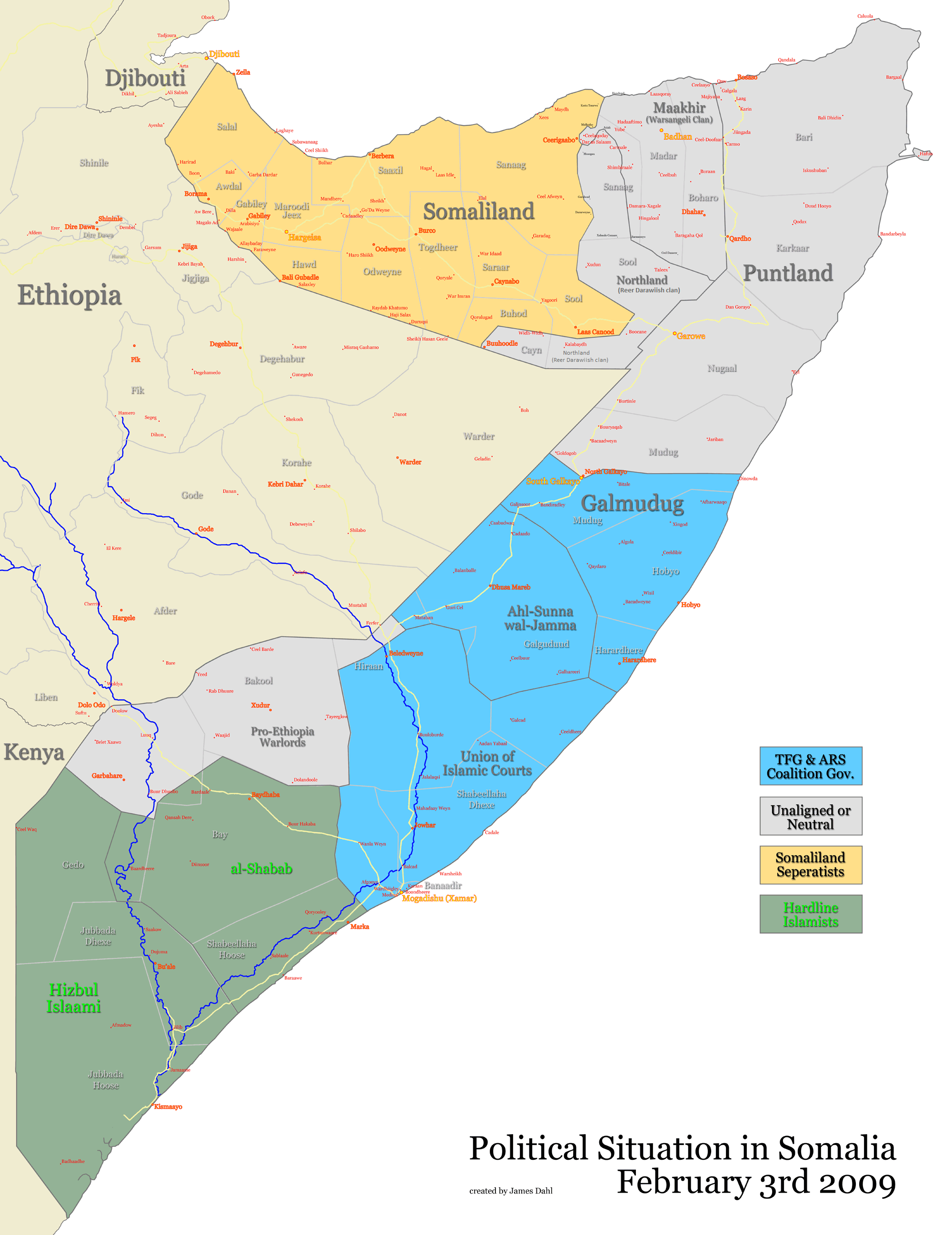
Blue = TFG & ARS Coalition Gov.
Green = Anti Government Apposition.
Puntland & Waqooyi are excluded for they have a functioning MaaMuL.
 http://upload.wikimedia.org/wikipedia/c ... drawal.png
Re: Political Map Of Somalia
Posted: Thu Jul 02, 2009 11:05 pm
by FAH1223
james has to update

Re: Political Map Of Somalia
Posted: Thu Jul 02, 2009 11:26 pm
by zingii
FAH1223 wrote:james has to update
You lost there dude.

Re: Political Map Of Somalia
Posted: Thu Jul 02, 2009 11:27 pm
by FAH1223
zingii wrote:FAH1223 wrote:james has to update
You lost there dude.
JAMES DAHL made that map, he gotta update
Re: Political Map Of Somalia
Posted: Thu Jul 02, 2009 11:30 pm
by zingii
Now we on the same page.
Anyways who controls where now?
Re: Political Map Of Somalia
Posted: Thu Jul 02, 2009 11:47 pm
by Kanada
Yeah, alshabab/xisbul islam pretty much control shabelle dexe. Islamic courts of hiiraan recently switched sides to xisbul Islam. Al shabab/xisbul islam have a strong influence in galgudud since karbashing ahlu sunnah wal jameca in wabxo. If the Ethiopians dont interefere they will capture galgugu soon.
They are surrounding mogadishu from all sides and are cutting off the escape routes of the tgf on land. If they somehow defeat the tgf in mogadisho(highly unlikely) everything else will be a cake walk.
Re: Political Map Of Somalia
Posted: Sat Jul 11, 2009 9:30 pm
by James Dahl
I don't have enough time to update that map anymore. I tried to keep track of everything that was going on but it was too much work and always ended up being kind of inaccurate anyways :/
Re: Political Map Of Somalia
Posted: Sat Jul 11, 2009 9:33 pm
by FAH1223
James Dahl wrote:I don't have enough time to update that map anymore. I tried to keep track of everything that was going on but it was too much work and always ended up being kind of inaccurate anyways :/
you need to seriously delete the TFG sphere of influence and just flat out replace it with Puntland and Al Shabaab in the central regions v. Ahlu Sunnah group
and Shabaab has everything south and west of benadir
Re: Political Map Of Somalia
Posted: Sun Jul 12, 2009 5:40 pm
by James Dahl
FAH1223 wrote:James Dahl wrote:I don't have enough time to update that map anymore. I tried to keep track of everything that was going on but it was too much work and always ended up being kind of inaccurate anyways :/
you need to seriously delete the TFG sphere of influence and just flat out replace it with Puntland and Al Shabaab in the central regions v. Ahlu Sunnah group
and Shabaab has everything south and west of benadir
Puntland hasn't repudiated the central government as far as I am aware, and I don't know the exact spheres of influence involved anymore.
If you've got photoshop I'll send you the source file, if anyone else is willing to take up the task.
Re: Political Map Of Somalia
Posted: Sun Jul 12, 2009 5:43 pm
by oldenglish
James Dahl wrote:FAH1223 wrote:James Dahl wrote:I don't have enough time to update that map anymore. I tried to keep track of everything that was going on but it was too much work and always ended up being kind of inaccurate anyways :/
you need to seriously delete the TFG sphere of influence and just flat out replace it with Puntland and Al Shabaab in the central regions v. Ahlu Sunnah group
and Shabaab has everything south and west of benadir
Puntland hasn't repudiated the central government as far as I am aware, and I don't know the exact spheres of influence involved anymore.
If you've got photoshop I'll send you the source file, if anyone else is willing to take up the task.
The map you created and the territory marked as Maakhir is based on Warsangeli inhabited land?
Somaliland does not control lands west of Erigavo.
Re: Political Map Of Somalia
Posted: Sun Jul 12, 2009 5:49 pm
by Osman-NZ
Zinji, don't fall for this crap on snet...makhir is apart of puntland..who u think ilkajir is, warsans are at puntland functions always..snet looma baxoo...i saw that map u posted like u think its serious.
Re: Political Map Of Somalia
Posted: Sun Jul 12, 2009 5:54 pm
by oldenglish
Osman-NZ wrote:Zinji, don't fall for this crap on snet...makhir is apart of puntland..who u think ilkajir is, warsans are at puntland functions always..snet looma baxoo...i saw that map u posted like u think its serious.
Maakhir is not part of Puntland dont confuse Darood for anything else. From the Highway line joining to Qardho all lands belong to Maakhir and have nothing to do with Puntland administration, Warsan isnt 1 man and Ilka Jir/TFG Ministers/Somaliland ministers have nothing to do with Maakhir nor is it part of them and is only part of Somalia by mouth.
Re: Political Map Of Somalia
Posted: Sun Jul 12, 2009 6:08 pm
by Shirib
Re: Political Map Of Somalia
Posted: Sun Jul 12, 2009 6:09 pm
by Unclebin-
James Dahl send me the source file.
Re: Political Map Of Somalia
Posted: Sun Jul 12, 2009 6:27 pm
by FAH1223
James, I don't got photoshop... I know a gearhead, good guy who could do it for me though
and yeah Puntland supports the TFG but dude, you have the map seem like the TFG controls Puntland
unclebin, how'd you shape the map
