Page 1 of 2
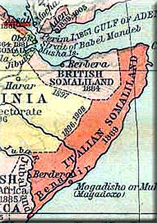
Look at this Somalia political map
Posted: Sun Jul 01, 2012 9:52 pm
by waryaa
I don't know who created it or its origins, just snatched from one of thug's topics. It puts Garowe, Qardo and Bosaso on the line that divides Somaliland and Puntland. It puts suburbans of these towns inside Somaliland. Looks like it has been floating around facebook circles.
My question is does this map represent the actual border between the two European colonizers, England and Italy?

Re: Look at this Somalia political map
Posted: Sun Jul 01, 2012 10:28 pm
by FBISOMALIA
What you think ...???
Re: Look at this Somalia political map
Posted: Mon Jul 02, 2012 10:08 am
by Khalid Ali
This map was first showed begin this year its the national geographic map
Its the actual map its where the border ends the Anglo Italian border between Somaliland and Somalia.
Here is another one

Re: Look at this Somalia political map
Posted: Mon Jul 02, 2012 10:25 am
by Khalid Ali
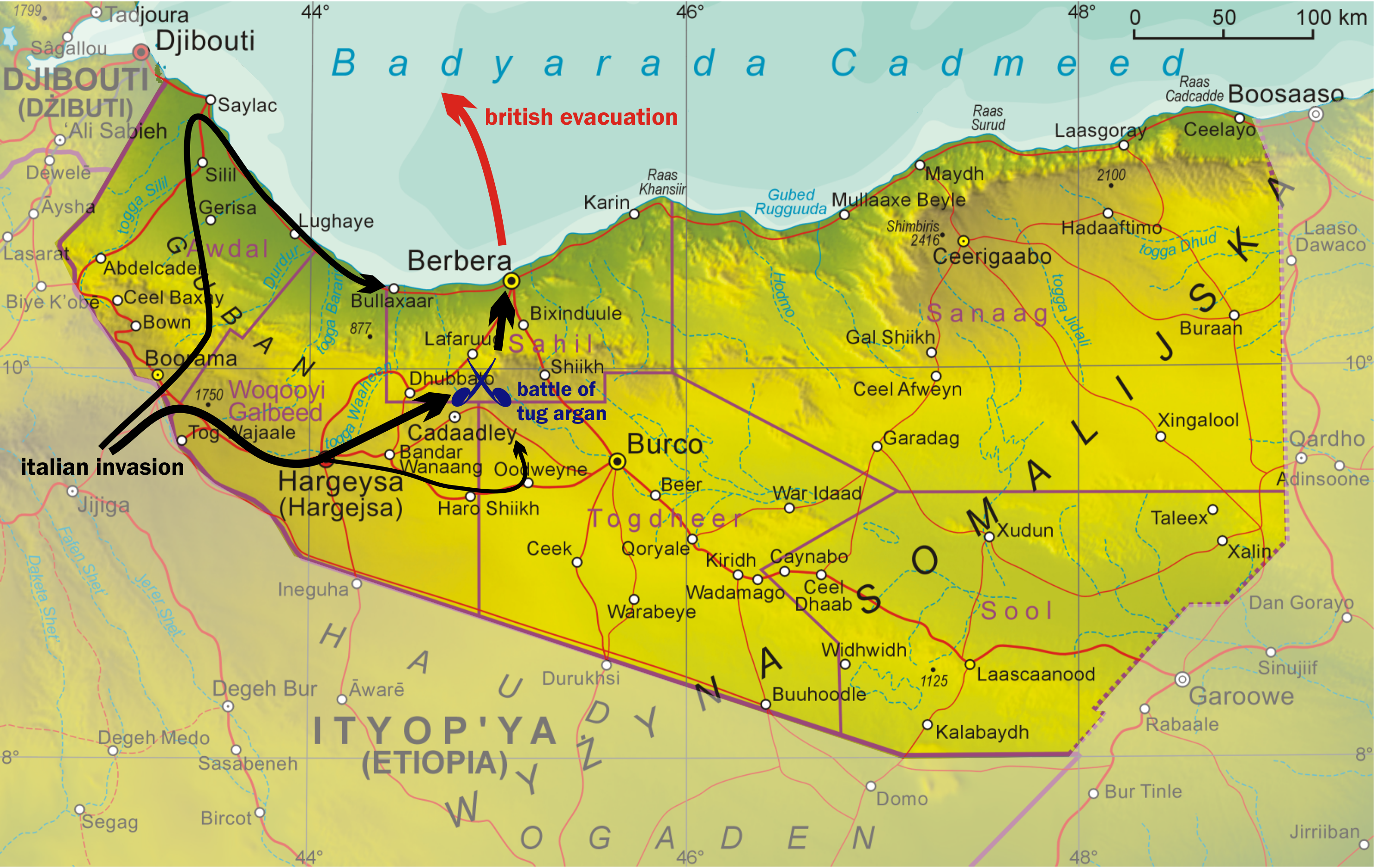
This one is much closer see if u remove the dot from Garowe its perfect the border between Somaliland and Somalia is 5 km from Garowe
8 Km From bosaaso. The qardho part is perfect

The thing is Waryaa Qardho grew the past 10 years towards the west thats why u will see some maps Qardho so close to the Somaliland border.
Re: Look at this Somalia political map
Posted: Mon Jul 02, 2012 10:41 am
by Thuganomics
Re: Look at this Somalia political map
Posted: Mon Jul 02, 2012 12:25 pm
by waryaa
FBI, what I or you think doesn't count. It was a question that didn't need thinking.
So guys, if these borders are legit historic maps and the borderline is correct, then Somaliland is missing a good junk of land. If that's the case, instead of SSC, Khatumo, etc., anti-sland-establishment Harti ppl under British rule can claim their own Somaliland state with Las Ano as the capital. Two Somalilands, two flags. It would be fun to see khatumo name replaced by "The real Somaliland". Like housewives and the real housewives TV shows.
Re: Look at this Somalia political map
Posted: Mon Jul 02, 2012 2:57 pm
by Chinaman
Parts of Qardho like Kubo and the farms along with some tuulos that are part of degaanka qardho (Dhaxan, Weylo etc) were originally part of the former British Somaliland. If you go north, degaanka waaciye was part as well.
Near Bosaaso the border is in Bandar Ziyada/Qaw which was actually destroyed by the British because it sat right on the border betwen the two but has since been rebuilt:
Their main center of business was the town of Bander Ziyada. This city was destroyed and abandoned by the British colonialists when colonial rule divided the Somali territory into five parts[2] since it lay on the border line between British Somaliland and Italian Somaliland.
Re: Look at this Somalia political map
Posted: Mon Jul 02, 2012 3:14 pm
by tightrope
Chinaman wrote:Parts of Qardho like Kubo and the farms along with some tuulos that are part of degaanka qardho (Dhaxan, Weylo etc) were originally part of the former British Somaliland. If you go north, degaanka waaciye was part as well.
Near Bosaaso the border is in Bandar Ziyada/Qaw which was actually destroyed by the British because it sat right on the border betwen the two but has since been rebuilt:
Their main center of business was the town of Bander Ziyada. This city was destroyed and abandoned by the British colonialists when colonial rule divided the Somali territory into five parts[2] since it lay on the border line between British Somaliland and Italian Somaliland.
GREAT! NOW THE QAT-ADDICTS ARE GOING TO TRY TO CLAIM QARDHO FARMS AND PL NAVAL BASE

Re: Look at this Somalia political map
Posted: Mon Jul 02, 2012 3:45 pm
by Cirwaaq
The oil isn't flowing yet it is too early for war...
I suspect oil production will occur simultaneously in both states and the expansionist ideals of Gerowe will one day serve a higher purpose for non-somali actors.
War is coming it is just a matter of time...


Re: Look at this Somalia political map
Posted: Mon Jul 02, 2012 3:52 pm
by tightrope
^^
YOU'RE CALLING PUNTLANDERS EXPANSIONISTS?

ISAAQ ARE THE ONES TRYING TO CLAIM WARSANGELI AND DHULBAHANTE LAND.
Re: Look at this Somalia political map
Posted: Mon Jul 02, 2012 4:05 pm
by Cirwaaq
tightrope wrote:^^
YOU'RE CALLING PUNTLANDERS EXPANSIONISTS?
ISAAQ ARE THE ONES TRYING TO CLAIM WARSANGELI AND DHULBAHANTE LAND.
You and me can discuss it all we want according to international law and the AU charter and that which constitutes a Mordern state border. Puntland is in voilation of the border of it's neighbour.
Now you might think it smart or rather funny to twist your delusion and make it someone else's fault but in the long run you are denying ALL those we left behind in the Desert a chance to live in peace.
Respect the borders of your neighbours... If you are true in your quest to free land belonging to somali people then please go free NFD and Ogadeen first.
Re: Look at this Somalia political map
Posted: Mon Jul 02, 2012 4:08 pm
by AgentOfChaos
The short answer is no.
Re: Look at this Somalia political map
Posted: Mon Jul 02, 2012 4:40 pm
by tightrope
Cirwaaq wrote:tightrope wrote:^^
YOU'RE CALLING PUNTLANDERS EXPANSIONISTS?
ISAAQ ARE THE ONES TRYING TO CLAIM WARSANGELI AND DHULBAHANTE LAND.
You and me can discuss it all we want according to international law and the AU charter and that which constitutes a Mordern state border. Puntland is in voilation of the border of it's neighbour.
Now you might think it smart or rather funny to twist your delusion and make it someone else's fault but in the long run you are denying ALL those we left behind in the Desert a chance to live in peace.
Respect the borders of your neighbours... If you are true in your quest to free land belonging to somali people then please go free NFD and Ogadeen first.

WHY WOULD I RESPECT BORDERS CREATED BY EUROPEAN COLONIALISTS?
SOMALIA AND SOMALILAND NEVER EXISTED BEFORE BRITS AND ITALIAN INVADED.
TELL YOUR QAT-ADDICTED MASTERS TO RESPECT CLAN BORDERS.
Re: Look at this Somalia political map
Posted: Mon Jul 02, 2012 4:42 pm
by The_Emperior5
Tightrope if that's the case why the hell do you respect the Italian Abyssinian border between ur Puntland and Ethiopia, i believe there are Majeerteens in wardheer biciydyahan and cumar maxamuud?
Re: Look at this Somalia political map
Posted: Mon Jul 02, 2012 4:48 pm
by Cirwaaq
tightrope wrote:Cirwaaq wrote:tightrope wrote:^^
YOU'RE CALLING PUNTLANDERS EXPANSIONISTS?
ISAAQ ARE THE ONES TRYING TO CLAIM WARSANGELI AND DHULBAHANTE LAND.
You and me can discuss it all we want according to international law and the AU charter and that which constitutes a Mordern state border. Puntland is in voilation of the border of it's neighbour.
Now you might think it smart or rather funny to twist your delusion and make it someone else's fault but in the long run you are denying ALL those we left behind in the Desert a chance to live in peace.
Respect the borders of your neighbours... If you are true in your quest to free land belonging to somali people then please go free NFD and Ogadeen first.
WHY WOULD I RESPECT BORDERS CREATED BY EUROPEAN COLONIALISTS?
SOMALIA AND SOMALILAND NEVER EXISTED BEFORE BRITS AND ITALIAN INVADED.
TELL YOUR QAT-ADDICTED MASTERS TO RESPECT CLAN BORDERS.
There then is only one outcome in the end...

Kill or be killed and the international world is on the side of those who defend their legitimate borders... I hope you are waiting on the border when shit kicks off and not in the comfort of some other country.