Page 1 of 3
Mapping history
Posted: Mon Nov 25, 2013 10:07 pm
by James Dahl
I tried this years ago and it wasn't terribly successful, but I feel like I've learned a lot more since then, and I would like to try again.
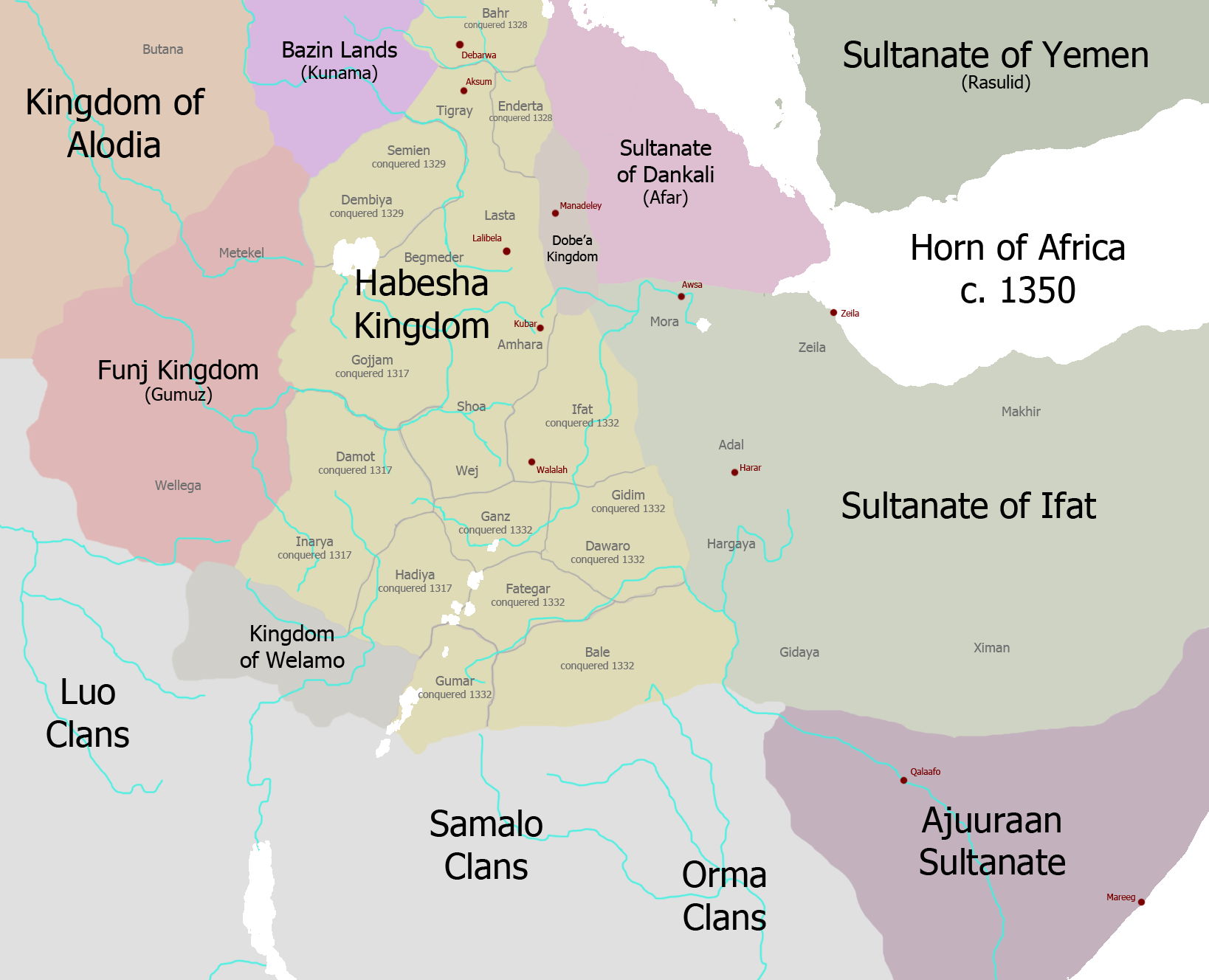
This map is for just before the campaigns of Amde Seyon, who radically altered this map. My next map will be of after Amde Seyon's conquests so about 1350.

Re: Mapping history
Posted: Mon Nov 25, 2013 10:15 pm
by Arabman
Mr. Dahl, what software do you use for the mapping?
Re: Mapping history
Posted: Tue Nov 26, 2013 12:02 am
by James Dahl
I just use photoshop cs2
Re: Mapping history
Posted: Tue Nov 26, 2013 1:45 am
by James Dahl
I am relatively confident about the Ethiopia area, though I'm not sure about the south of Ajuuraan, I don't know when exactly the Ajuuraan dominion over the south occurred, maybe someone knows more about the chronology of Ajuuraan vs Orma wars aka "Gaal Madow Wars". Also I think Ifat's authority over anything east of Berbera was pretty vague.
Re: Mapping history
Posted: Tue Nov 26, 2013 8:29 am
by LiquidHYDROGEN
Wow Somaliweyne is huge.

Re: Mapping history
Posted: Tue Nov 26, 2013 8:33 am
by Khalid Ali
Sultanate of Ifat kinda looks like greater Somaliland , who knows maybe in the future we can annex Djibouti the Hawd and reserve area and the afriaaan qallo oromo and the hararis. And call it the republic of Adalonia. By the way the luo clans almost live near the dinkas at that time.
Re: Mapping history
Posted: Tue Nov 26, 2013 8:52 am
by LiquidHYDROGEN
^^^^I prefer the "Empire of Adal"
Re: Mapping history
Posted: Tue Nov 26, 2013 9:07 am
by ToughGong
Luo clans kuna yeey ahayeen
Re: Mapping history
Posted: Tue Nov 26, 2013 9:09 am
by DayaxJeclee
The map is 600-700 years old. You just colour them. Credit the author of this map.
Re: Mapping history
Posted: Tue Nov 26, 2013 9:41 am
by DayaxJeclee
ToughGong wrote:Luo clans kuna yeey ahayeen
Like soomaali, colonial divided them. So you will find luo in kenya, uganda, sudan and in tanzania. Even some in ethiopia bashungul gumaz region.
Re: Mapping history
Posted: Tue Nov 26, 2013 1:36 pm
by Gabre
ToughGong wrote:Luo clans kuna yeey ahayeen
Waa beesha Garaad Barack Hussein Obama Xafidullah. Qowmiyad laandheer
Re: Mapping history
Posted: Wed Nov 27, 2013 5:29 pm
by James Dahl

Here is the next map, after Amde Seyon's conquest of Damot, Enderta and Eritrea, his invasion of Beta Israel, then his conquest of the south after defeating the Islamic Alliance at the Battle of Das.
I wonder how different history would have been if the alliance Sultan Jamaluddiin had brought together had won.
Re: Mapping history
Posted: Wed Nov 27, 2013 6:55 pm
by BuuloXubeey
Thanks James, these maps look interesting. It would be nice if we could see where the Ajuraan Sultante ended from the south. What about the NFD area of East Africa at that time. Was it under Ajuraan sultante?
Re: Mapping history
Posted: Wed Nov 27, 2013 7:16 pm
by James Dahl
BuuloXubeey wrote:Thanks James, these maps look interesting. It would be nice if we could see where the Ajuraan Sultante ended from the south. What about the NFD area of East Africa at that time. Was it under Ajuraan sultante?
Thanks

The second river in the south of the Ajuuraan there is the Jubba, they conquered the Jubba Valley in the conquest of the south up to the Tana River, but no further south than that, the northern NFD was forming the Oromo confederations, the southern NFD was part of the Ajuuraan Sultanate.
The border area between Kenya and Ethiopia is the Oromo homeland that the Habesha called "Barzamo" or beyond the water (the water being the Jubba River's tributaries). Oromo history calls this land "Madda Walaabu".
Re: Mapping history
Posted: Wed Nov 27, 2013 8:07 pm
by BuuloXubeey
Yeah seems interesting. Cause I have learnt of the Ajuraan sultante and Omani (Kenya/Tanzania coastal) had some sort of network. So I guess they had a border with the sultante in southern NFD.