


One of the most impressive ones that I have seen myself is the Daroor dam (there's four of them but one is huge). In fact, I will post its measurements from satellite imaginary.
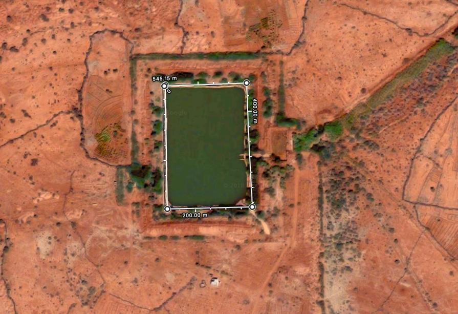
200m x 545m and I say it's at least 10-20m deep depending on which end.
It has its own pipe system and pumps.
Here is a picture

The water is clean because it has upper drainage cleaning system (gravity where all the mud and tree branches are left behind). It also has huge plastic liner as well as cement.
Here is one in Dhuxun in Nogob
These are the Darood towns and villages:
I have been to most of them. Shandarbi is very unique memory for me because its landscape and plants are quite different from towns and villages to its north including Daroor. It used to be very dense bushland. I can't remember the plant names but lebi is one of the trees that is found abundantly there as well as fooxa (south of Daroor is where you start to see it, forgot the name of that area but just before Godiirgalka).1:Kaaam-tuug
2:Bissad
3:Abokor
4: Isgoyska
5: Qooryare
6: Aadan-waraabe
7: Cigaal Caddaaani Warta
8: Raybad-lay
9: Kaaam-iidle
10: Bariiqo
11: Gufays
13: Kaam-liiban
14: Kaam-xasan
15: Dibiga
16: Laanqayrta
17: Sanqoole
18: Dhagamale
19: Gaaashanka
20: Ina guuxa
21: Libaax- qawdhama
22: Higlada
23: Karoos Wayne
24: Karoos Yare
25: Kaaam rooble
26: Kaam maxamed ka koowad
27: Kaaam maxamadka labaad
28: Kaam buraaale
29: Habaas wayn
30: Ergin
31: Laf wacays
32: Gocon dhalay
33: Haradidino
34: Laanqayrta -raydab ardaale
35: Qool-buulale
36: Xabashi
37: Rabaso
38: Celiyo
39: Garagarada
40: Laf-xagarey
41: Dundumo cad
42: Wadada cas
43: Aaarjoog
44: Shabeelle
45: Labbida
46: Kamarooyaan
47: Kuus haybe
48: Cabdiyuusuf
49: Waabacado
50:BOA
51: Daroor
52: Shandarbi
53: Qaydar habeed
54: Ina dhoola yare
55: Ina Cali-ogaadeen
56: Goosayga
57: Winiiqa
58: Sheeekh yoonis
59: Bali-guuyoobe
60: Goodirgalka - one of my favorite places, it had this swimming pool on rocks
61: Cunaqabad
62: Dekedda
63: Ina malow
64: Magaaalo xaaji
65: Bali jaaaqur
66: Qaydarka jufka
67: Afar irdood
68: Esgoys Bari.
69: Burco-duurey
70: Gadhwayne
71: Xaabxume.
72: Bali-Cabdi
73: Sugunta
74: Cadaada
My memory of Dekadda was it was dry place. Anything west of that is cattle country. You start seeing a lot of cows.
I travelled all over the place with my abtis and father. The most southern I went was probably south of Shekosha----beautiful land. Very green and full of those seasonal rivers (toga). What I recall was it had dhabiga tree. Small tree which Somalis use to make bakoorad due to its flexibility and durance. The landscape in the video below reminds me of that region the most (could be there or near it); a lot of tog rivers there, mountains mostly small. In the southeast you could go to Moholin then travel south to dulcad (not the refugee camp near Kebri Bayax), Dubdheer, etc.
I remember Rabaso too. In the north of the town it's mostly farm land (dooxada) and going southwest is Maaxato. Going north you going to end up in Bali-Cabdi.
Here is the schooling system in Rabaso. The region is improving nicely and the government is concerned about the people genuinely. There are things that need much closer attention but the government deserves to be applaud. The healthcare center in Rabaso can serve for 25,000 people. The reer Hawd people need to do their part.
The school has 18 teachers and can class 500 students at any given time. I'm impressed with Rabaso. It used to be much smaller than Daroor and even Gosayga. What I also recall about Rabaso as a kid is there's huge arms dump---you see tanks, shells, cannons, artillery in the bushlands well rusted. I never knew there was a war but as I grew up and learned about 1977, it makes sense. We can say it was one of the biggest battle grounds.
I will bring photos. I'm going to despatch a team from Hargeisa
I'm a man close to nature.
I love the Hawd. This is where my heart is always.
